NAVIGATION SYSTEM > SYSTEM DESCRIPTION |
| NAVIGATION SYSTEM OUTLINE |
Vehicle position tracking methods
It is essential that the navigation system correctly tracks the current vehicle position and displays it on the map. There are 2 methods to track the current vehicle position: autonomous (dead reckoning) and GPS* (satellite) navigation. Both navigation methods are used in conjunction with each other.
*GPS (Global Positioning System)
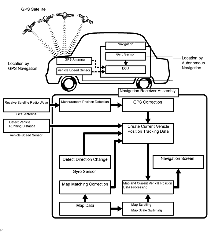
| Operation | Description |
| Vehicle Position Calculation | The navigation receiver assembly calculates the current vehicle position (direction and current position) using the direction deviation signal from the gyro sensor and the running distance signal from the vehicle speed sensor and creates the driving route. |
| Map Display Processing | The navigation receiver assembly displays the vehicle track on the map by processing the vehicle position data, vehicle running track and map data from the map disc. |
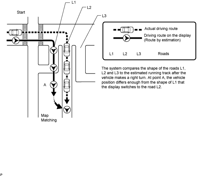
| Map Matching | The map data from the map disc is compared to the vehicle position and running track data. Then, the vehicle position is matched with the nearest road. |
| GPS Correction | The vehicle position is matched to the position measured by GPS. Then, the GPS measurement position data is compared with the vehicle position and running track data. If the position is widely different, the GPS measurement position is used. |
| Distance Correction | The running distance signal from the vehicle speed sensor includes the error caused by tire wear and slippage between the tires and road surface. Distance correction is performed to account for this. The navigation receiver assembly automatically offsets the running distance signal to make up for the difference between it and the distance data of the map. The offset is automatically updated. |
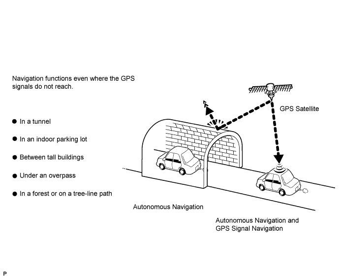
Autonomous navigation
This method determines the relative vehicle position based on the running track determined by the gyro located in the navigation receiver assembly and the vehicle speed sensor signal.
Gyro sensor
Used to calculate the direction by detecting angular velocity. It is located in the navigation receiver assembly.
Vehicle speed sensor signal
Used to calculate the vehicle running distance.
GPS* navigation (Satellite navigation)
This method detects the absolute vehicle position using radio waves from GPS satellites.
*GPS satellites were launched by the U.S. Department of Defense for military purposes.
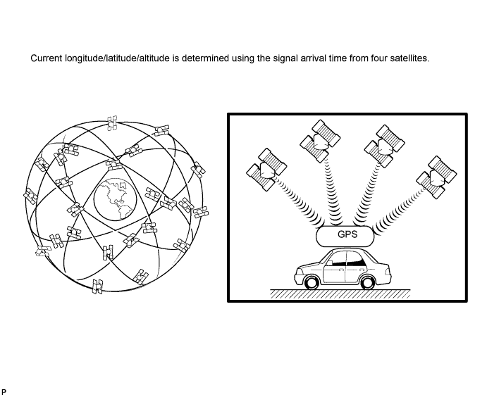
| Number of Satellites | Measurement | Description |
| 2 or less | Measurement impossible | Vehicle position cannot be obtained because the number of satellites is not enough. |
| 3 | 2-dimensional measurement is possible | Vehicle position is obtained based on the current longitude and latitude. (This is less precise than 3-dimensional measurement.) |
| 4 | 3-dimensional measurement is possible | Vehicle position is obtained based on the current longitude, latitude and altitude. |
Map matching
The current driving route is calculated by autonomous navigation (according to the gyro sensor and vehicle speed sensor) and GPS navigation. This information is then compared with possible road shapes from the map data in the map disc and the vehicle position is set onto the most appropriate road.
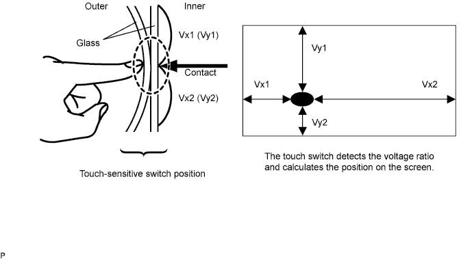
Touch switch
Touch switches are touch-sensitive (interactive) switches operated by touching the screen. When a switch is pressed, the outer glass bends in to contact the inner glass at the pressed position. By doing this, the voltage ratio is measured and the pressed position is detected.

| CD (COMPACT DISC) PLAYER OUTLINE |
A compact disc player uses a laser pickup to read digital signals recorded on a compact disc (CD). By converting the digital signals to analog, it can play music and audio.
Usable discs
This player can play only audio CDs, CD-Rs (CD-Recordable), and CD-RWs (CD-ReWritable) that have any of the following marks:

Precautions for use of discs
![]() |
Cleaning
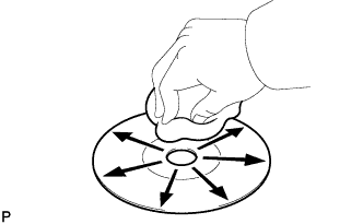
If dirt is on the disc surface, wipe it clean with a soft dry cloth such as an eyeglass cleaner for plastic lenses from the inside to the outside in a radial direction.
| MP3/WMA OUTLINE |
Playable MP3 file standards
| Compatible standard | MP3 (MPEG1 LAYER3, MPEG2 LSF LAYER3) |
| Compatible sampling frequency |
|
| Compatible bit rate |
|
| Compatible channel mode | Stereo, joint stereo, dual channel, monaural |
Playable WMA file standards
| Compatible standard | WMA Ver. 7, 8, and 9 |
| Compatible sampling frequency | 44.1, 48 (kHz) |
| Compatible bit rate |
|
ID3 tag and WMA tag
Additional textual information called ID3 tag can be input to MP3 files. Information such as song titles and artist names can be stored.
Additional textual information called WMA tag can be input to WMA files. Information such as song titles and artist names can be stored.
Usable media
Only CD-ROMs, CD-Rs (CD-Recordable), and CD-RWs (CD-ReWritable) can be used to play MP3/WMA files.
Usable media format
Usable media format
| Disc format | CD-ROM Mode 1, CD-ROM XA Mode 2 Form 1 |
| File format | ISO9660 Level 1 and Level 2 (Joliet, Romeo) |
Standard and restrictions
| Maximum directory levels | 8 levels |
| Maximum number of characters for a folder name/file name | 32 characters |
| Maximum number of folders | 192 (Including empty folders, route folders, and folders that do not contain MP3/WMA files) |
| Maximum number of files in a disc | 255 (Including non-MP3/WMA files) |
File names
Only files with an extension of ".mp3" or ".wma" can be recognized and played as MP3 or WMA files.
Save MP3 or WMA files with an extension of ".mp3" or ".wma".
| "Bluetooth" OUTLINE |

"Bluetooth" is a trademark owned by Bluetooth SIG. Inc.
"Bluetooth" is a wireless connection technology that uses the 2.4 GHz frequency band.
Hands-free function
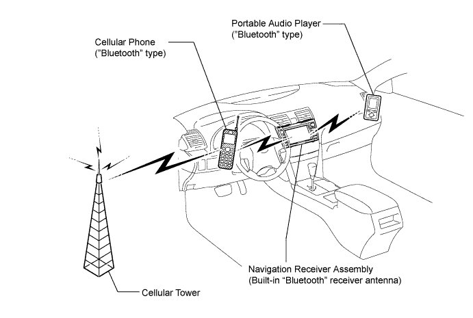
The "Bluetooth" built-in navigation receiver assembly and a "Bluetooth" compatible cellular phone*1 can be connected using a "Bluetooth" wireless connection. This enables use of the hands-free function on the cellular phone even the phone may be in a pocket or bag. For this reason, it is not necessary to use a connector or cable to connect the cellular phone.
*1: Some versions of "Bluetooth" compatible cellular phones may not function.
"Bluetooth" audio function
The "Bluetooth" built-in navigation receiver assembly and a "Bluetooth" compatible portable audio player*2 can be connected using a "Bluetooth" wireless connection. This enables files stored in the portable audio player to be heard from the vehicle speakers. In addition, operations such as play/stop can be performed directly from the navigation receiver assembly.
*2: Some versions of "Bluetooth" compatible audio players may not be able to operate the "Bluetooth" function, or music may play, but functions available using the navigation receiver assembly may be limited.
Available "Bluetooth" audio devices
| Required "Bluetooth" specifications | Ver. 1.1, or higher (Recommended: Ver. 2.0+EDR or higher) |
| Compatible profiles |
|
| Maximum number of audio devices that can be registered | 2 |
| RADIO DESCRIPTION |
Radio frequency band
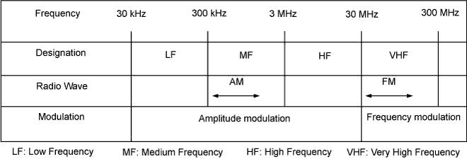
Radio broadcasts use the radio frequency bands shown in the table below.

![]() |
Service area
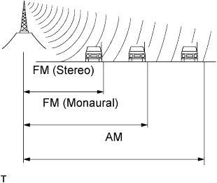
The service areas of AM and FM broadcasts are vastly different. Sometimes an AM broadcast can be received very clearly but an FM stereo cannot. FM stereo has the smallest service area, and is prone to pick up static and other types of interference such as noise.
Radio reception problems
![]() |
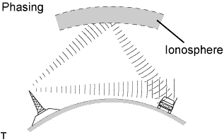
Phasing
AM broadcasts are susceptible to electrical interference and another kind of interference called phasing. Occurring only at night, phasing is the interference created when a vehicle receives 2 radio wave signals from the same transmitter. One signal is reflected off the ionosphere and the other signal is received directly from the transmitter.
![]() |
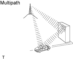
Multipath
Multipath is a type of interference created when a vehicle receives 2 radio wave signals from the same transmitter. One signal is reflected off buildings or mountains and the other signal is received directly from the transmitter.
![]() |
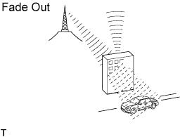
Fade out
Fade out is caused by objects (buildings, mountains and other such large obstacles) that deflect away part of a signal, resulting in a weaker signal when the object is between the transmitter and vehicle. High frequency radio waves, such as FM broadcasts, are easily deflected by obstructions. Low frequency radio waves, such as AM broadcasts, are less likely to deflect.
Noise problem
Technicians must have a clear understanding about each customer's noise complaint. Use the following table to diagnose noise problems.
| Radio Frequency | Noise Occurrence Condition | Presumable Cause |
| AM | Noise occurs in a specified area | Foreign noise |
| AM | Noise occurs when listening to an intermittent broadcast | An identical program transmitted from multiple towers can cause noise where the signals overlap |
| AM | Noise occurs only at night | Signal phasing |
| FM | Noise occurs while driving in a specified area | Multipath noise resulting from a change in FM frequency |
| AUTOMATIC SOUND LEVELIZER (ASL) FUNCTION OUTLINE |
The Automatic Sound Levelizer (ASL) function automatically adjusts the sound volume in order to enable clear audio quality even when vehicle noise increases (as vehicle noise increases, the volume is turned up, etc.).
Vehicle speed signals are received from the combination meter assembly and used for the ASL control.
| DIAGNOSTIC FUNCTION OUTLINE |
The navigation system has a diagnostic function (the result is indicated on the master unit).
| DIAGNOSIS DISPLAY DETAILED DESCRIPTION |
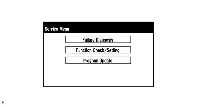
Service Menu Screen

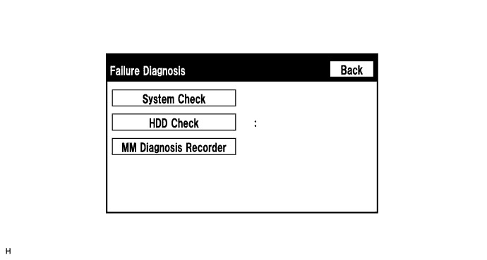
Failure Diagnosis Screen

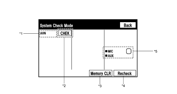
System Check Mode Screen

| Name | Component | Connection Method |
| AVN | Navigation receiver assembly | - |
| Result | Meaning | Action |
| OK | The device does not respond with a DTC. | - |
| EXCH | The device responds with a "replace"-type DTC. | Look up the DTC in "Unit Check Mode" and replace the device. |
| CHEK | The device responds with a "check"-type DTC. | Look up the DTC in "Unit Check Mode". |
| NCON | The device was previously present, but does not respond in diagnostic mode. | - Check power supply wire harness of the device. - Check the AVC-LAN communication line of the device. |
| NRES | The device responds in diagnostic mode, but gives no DTC information. | - Check power supply wire harness of the device. - Check the AVC-LAN communication line of the device. |
| Name | Component | Connection Method |
| MIC | Telephone microphone assembly | Vehicle wire harness |
| AUX | Stereo jack adapter | Vehicle wire harness |
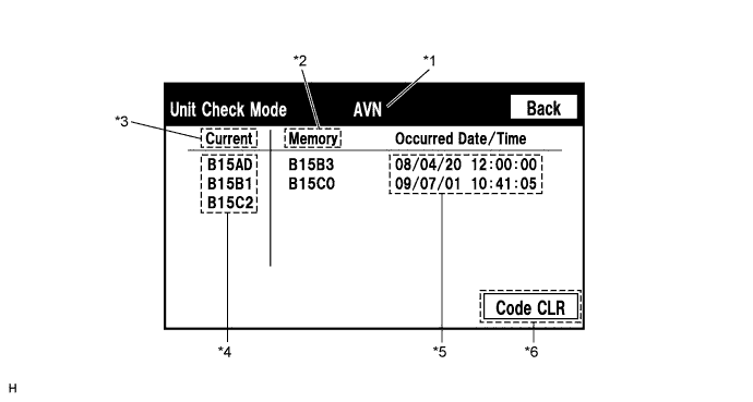
Unit Check Mode Screen

| Display | Content |
| *1: Device name | Target device |
| *2: History DTC | Diagnostic memory results and stored DTCs are displayed. |
| *3: Present DTC | DTCs output in the service check are displayed. |
| *4: DTC | DTC (Diagnostic Trouble Code) |
| *5: Timestamp | The time and date of history DTCs are displayed. (The year is displayed in 2-digit format.) |
| *6: Diagnosis clear switch | Pushing this switch for 3 seconds clears the diagnostic memory data of the target device. (Both response to diagnostic system check result and the displayed data are cleared.) |
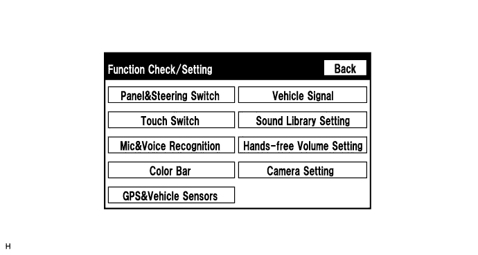
Function Check/Setting Screen

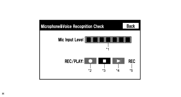
Microphone&Voice Recognition Check Screen

| Display | Content |
| *1: Microphone input level meter | Monitors the microphone input level every 0.1 sec. and displays the results in 8 different levels. |
| *2: Recording switch | Starts recording. |
| *3: Stop switch | Stops recording and playing. |
| *4: Play switch | Plays the recorded voice. |
| *5: Recording indicator | Comes on while recording. |
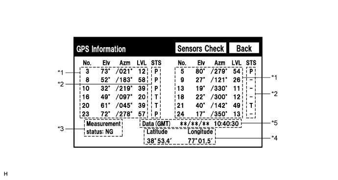
GPS Information Screen

| Display | Content |
| T | The system is receiving a GPS signal, but is not using it for location. |
| P | The system is using the GPS signal for location. |
| - | The system cannot receive a GPS signal. |
| Display | Content |
| 2D | 2-dimensional location method is being used. |
| 3D | 3-dimensional location method is being used. |
| NG | Location data cannot be used. |
| Error | Reception error has occurred. |
| - | Any other state. |
| Display | Content |
| Position | Latitude and longitude information on the current position is displayed. |
| Display | Content |
| Date | The date/time information obtained from GPS signal is displayed in Greenwich Mean Time (GMT). |
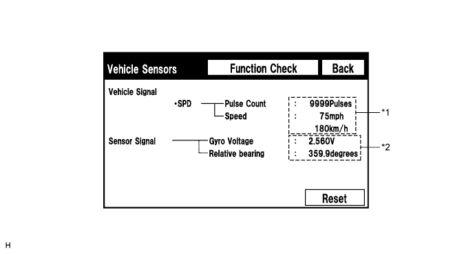
Vehicle Sensors Screen

| Display | Content |
| *1: SPD | SPD signal condition is displayed. |
| Display | Content |
| *2: Gyro sensor | Gyro sensor output condition is displayed. 2.1 to 2.9 V |
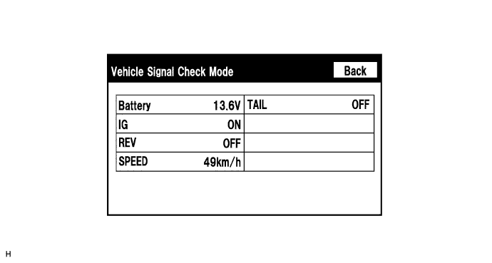
Vehicle Signal Check Mode Screen

| Display | Content |
| Battery | Battery voltage is displayed. |
| IG | IG switch ON/OFF state is displayed. |
| REV | Reverse signal ON/OFF state is displayed. |
| SPEED | Vehicle speed is displayed in km/h. |
| TAIL | Tail signal (Light control switch) ON/OFF state is displayed. |
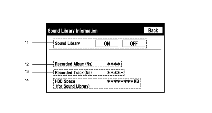
Sound Library Information Screen

| Display | Content |
| *1: Recording function setting for HDD | Recording to HDD permitted (ON)/not permitted (OFF) |
| *2: Number of albums | Number of albums recorded in HDD |
| *3: Number of tracks | Number of tracks recorded in HDD |
| *4: Free space in HDD | Free space in HDD partition for sound library |