NAVIGATION / MULTI INFO DISPLAY NAVIGATION SYSTEM / MULTI INFORMATION SYSTEM CONTROL NAVIGATION / MULTI INFORMATION
FUNCTION OF MAIN COMPONENTS
| Component | Function |
|---|---|
| Navigation Receiver Assembly | Receives and processes the data that is input from various components, displays various pieces of information and operating conditions on the screen, and provides voice guidance. |
| Navigation Antenna Assembly | Receives signals from GPS satellites and transmits them to the navigation receiver assembly. |
| Telephone Microphone Assembly | Transmits the voice input signals to the navigation receiver assembly. |
| Steering Pad Switch Assembly | Enables the user to operate the navigation system using the steering pad switches. |
| Park/Neutral Position Switch Assembly | Transmits the R position signals to the navigation receiver assembly. |
| Rear Television Camera Assembly | Captures the view behind the vehicle and transmits the image to the navigation receiver assembly. |
| No. 1 Stereo Jack Adapter Assembly | Transmits information from the portable audio player connected to the USB port or AUX port to the navigation receiver assembly. |
| Combination Meter Assembly | Transmits the vehicle speed signal to the navigation receiver assembly. |
FUNCTION
Navigation Screen
The navigation computer calculates the present position and direction of travel, determines a route and calculates the driving distance based on the following information sources:
Map data in the micro SD card
Global Positioning System (GPS) satellites
Built-in gyro sensor
Vehicle speed signal
Reverse signal
Parking brake signal
Traffic information signal* (models for U.S.A.)
Weather information signal* (models for U.S.A.)
- HINT:
-
*: Accessible using HD radio or Entune contents.
| Item | Function | |
|---|---|---|
| Map Display | 2D Map | Displays a normal 2-dimensional (2D) map. |
| Moving (Scrolling) Map | Scrolling the map is possible by flicking and dragging the screen. | |
| North Up/Heading Up | ·
If North Up is selected, north is always at the top of the map. ·
If Heading Up is selected, the direction the vehicle is traveling is at the top of the map. |
|
| 3D Display | Displays a 3-dimensional (3D) view of the map. | |
| 3D City Model Map | ·
Displays some areas of major cities on the 3-dimensional (3D) city model map when the map scale is set to 700 feet or less. ·
Always displayed in Heading Up mode. |
|
| Multi-step Scale Display | Changes the map scale in 14 steps. | |
| Direct Scale Change | Directly selects and displays the map scale. | |
| Street Name Indication on Scrolled Map | Displays the street name and city name even when the map screen is being scrolled. | |
| Footprint Map | Displays a major city in a scale of 25 m (82 ft.). | |
| Road Number Sign Board Display | Displays the road number on the map. | |
| Point Of Interest (POI) Display | Displays selected types of POIs as marks on the map. | |
| Speed Limit Display | Displays a speed limit icon on the map screen when driving on a major road. | |
| Multiple Display Function | Displays different modes on a screen that is split into 2 views. | |
| Compass Mode Screen | Displays the direction of travel and detailed data of the present location. | |
| Route Trace | ·
It is possible to store up to the last 200 km (124 miles) of a traveled route and retrace the route on the display. ·
Available when the map scale is set to 50 km (31 miles ) or less. |
|
| Route Guidance Demonstration | Demonstrates route guidance to the destination. | |
| Traffic Information Display* | Displays traffic data such as icons, arrows and indicators received using HD radio contents. | |
| Weather Information Display* | Displays realistic Doppler weather images received using HD radio contents. | |
| Traffic Prediction | Measures traffic using supplied forecast data and displays traffic predictions 15, 30 and 45 minutes into the future. | |
| New Route Map Display | Through the use of Dynamic Route Guidance (DRG), the user can compare and select either the current or new route when a new route is found using traffic jam and regulation information. | |
| Route Display | Displays route in different colors depending on traffic conditions. | |
| 3D Land Mark Display | Displays important landmarks in 3-dimensions (3D) for use when driving. | |
| Avoid Area Display | Displays a square centered on the user's designated point. | |
| Guidance Mark Display | Displays a mark on the map to support the user while driving. | |
| Off-route Arrow Display | When off route, displays an arrow in the direction of the destination. | |
| Day/Night Mode | Changes the map between day and night mode. | |
| Destination Search | Preset Destination Memory Search | A destination can be set from a pre-registered point while driving. |
| Address Search | A destination can be set in 2 ways:
·
Destination information can be entered in the following order: city name, street name and house number. ·
Destination information can be entered in the following order: house number, street name and city name. |
|
| POI Search | A destination can be set in 3 ways:
·
The name of a POI can be entered and then searched for from City or Category. ·
A POI category can be selected and a point of interest searched for near the present location, along the current route, near the city center or near the destination. ·
The phone number of a POI can be entered to search for it. |
|
| Street Name Body Search | A destination can be set by entering the body of a street name (suffix not required, but allowable). | |
| Previous Destination Search | Stores the coordinates, names, and dates of up to 100 locations that have been set as destinations in the past. | |
| Address Book (Memory Point) Search | A destination can be set from the registered Address Book (Memory Point). | |
| Emergency Search | Performs a specific search for police stations, hospitals, Toyota dealers and fire stations. | |
| Intersection or Freeway Entrance/Exit Search | A destination can be set in 2 ways:
·
By specifying 2 streets, the point at which they intersect is set as the destination point. ·
Searches for the destination by the name of the street that connects to a freeway entrance or exit. |
|
| Map Search | A destination can be set by using the cursor on the map. | |
| Coordinate Search | A destination can be input by entering its coordinates. | |
| Voice-recognition Search | A destination can be set up by voice command input. | |
| Return Home (Shortcut Search) | Displays a map of the area around the registered home and searches for a specific point. | |
| Entune Search | A point searched for using Entune content can be set as the destination. | |
| Street Name Abbreviation Search | Searches using a street name abbreviation. | |
| Route Search | Multiple Destination Setting | Multiple destinations can be set. The sequence of the destinations can be rearranged as well. |
| Multiple Route Search | Searches for multiple routes. | |
| Search Condition Designation | Searches for quick, alternate and short routes. | |
| Destination Reordering | Changes the order of destinations when more than one destination is selected. | |
| Detour Search | Changes the route to detour around a section of the route. | |
| Traffic Congestion Information Consideration | Performs searches which consider traffic congestion information. | |
| Avoidance Area | Automatically changes to another route to avoid heavy congestion. | |
| National Border Conscious Search | Searches for routes that do not cross the border of U.S.A., Canada or Mexico. | |
| Seasonal Restrictions Search | Search by choosing whether to use routes that pass through seasonally restricted areas. | |
| One-touch Home Search | Searches for the registered home with a single touch. | |
| Freeway Avoid Search | Searches for routes that do not use freeways. | |
| Recalculate Route | When the user vehicle deviates from the route while being guided by the navigation system, the system automatically searches for a new route using the current position. | |
| Alternate Road Search | Switches between using general roads and toll roads when performing a search from the currently traveled road. | |
| Set Waypoint | Up to 5 waypoints can be set. | |
| Guidance | Voice Guidance | Provides voice guidance about the distance and the direction of travel to a destination point based on road conditions and vehicle speed. |
| Next Turn Guidance | Provides guidance about the distance to the next turn and indicates the direction of the turn using an arrow. | |
| Freeway Mode Display | Displays the distance to the next junction and exit, or POIs in the area around a freeway exit. | |
| Real Freeway Junction Display | Displays the junction and signage in 3D in the area around a major junction while driving. | |
| Tollgate Guidance | Displays the junction and signage in 3D in the area around a major tollgate while driving. | |
| Shield Icon | Freeway shield icons will be displayed on the 3D guidance screen. | |
| Intersection Zoom-in Display | Zooms in the map display when approaching an intersection. | |
| Turn List Display | Displays a turn list on the right side of the 2-screen display. | |
| Arrow (Turn-by-turn) Display | Displays the direction of the next turn and the distance to the turn on the right side of the 2-screen display. | |
| Route Information Bar Display | Displays the following information:
·
Street name of the current location ·
Distance and travel time to the destination ·
Distance to the destination and estimated time of arrival ·
Distance to the destination and an arrow facing the destination (when off the route during guidance) |
|
| Guidance through Traffic Circles or Round-abouts | A special guidance can be given when driving in a traffic circle or when approaching a traffic circle. | |
| Guidance Point Junction Mark Display | Displays marks at the positions of junctions along the route on the map. | |
| Interval Guidance (Onroute Guidance) | After passing through a junction, provides voice guidance such as "Continue on this road for -- km". | |
| Junction Guidance | Provides guidance using voice guidance and maps when entering and leaving junctions. | |
| Guidance | Replay Guidance | Replays junction and other voice guidance by user operation (pressing the current position switch). |
| Arrival Guidance | Notifies the user by voice guidance when approaching the destination. | |
| Ferry Route Guidance | Ferry routes are displayed on the map using dotted lines. Provides voice guidance from general roads to the ferry terminal, and then reactivates guidance after getting off the ferry. | |
| Door-to-door Guidance | Provides voice guidance for narrow streets. | |
| T-intersection Shape Guidance | Provides voice guidance such as "Turn -- at the end of the road" when approaching a T-intersection. | |
| Total Route Diagram | Displays information such as the total distance to destination, distance traveled and ferry usage. | |
| Detailed Route Information | Displays the total distance to destination, distance traveled on toll roads, total cost and remaining time to destination in a list for each route. | |
| Route Starting Guidance | After a route is determined, voice guidance explaining the roads to travel and the destination is given. | |
| Estimated Arrival Time Display | Calculates and displays the estimated time of arrival based on the set average vehicle speed. When there are multiple destinations, it is possible to switch to displaying the estimated time of arrival and total distance to a waypoint. | |
| Remaining Distance Display | ·
Displays the remaining distance from the current location to the destination. ·
Displays the distance in a straight line from the current location to the destination when deviating from the navigation route. |
|
| Destination Direction Arrow | Displays the direction of the destination when deviating from the navigation route. | |
| Traffic Jam and Regulation Voice Guidance | Provides voice guidance for traffic information along the route. | |
| Guidance Pop-up | The user can enable or disable the automatic visual guidance pop-up display. | |
| Continue Guidance | Voice and visual guidance is given to urge the user to continue driving on the current freeway without accidently exiting to another freeway. This guidance is available only at the major freeway junctions. | |
| Others | Voice Recognition | Recognizes pre-programmed system commands spoken to operate the navigation system. |
| Map Coverage Information Display | Displays the map area that is stored on the micro SD card. | |
- HINT:
-
*: Only available in HD Radio broadcast areas.
Information Screen
The functions of the information screen are listed below:
| Item | Outline |
|---|---|
| Fuel Consumption | Information about fuel consumption per minute or per trip can be displayed. |
| Weather | Displays weather information and Doppler weather radar information of the current location or selected city while receiving data from HD radio*. |
| Traffic | Displays a list of incidents, estimated traffic information and traffic information on the stored route while receiving data from HD radio*. |
- HINT:
-
*: Only available in HD Radio broadcast areas.
The fuel consumption screen is displayed as illustrated below. This screen has the display functions listed below:
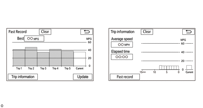
| Item | Outline | |
|---|---|---|
| (1) | Clear Switch | Clears all past information. |
| (2) | Best Fuel Consumption | Displays the best (most economical) fuel consumption per trip. |
| (3) | Trip Information Switch | Changes to the average fuel consumption per minute screen. |
| (4) | Average Fuel Consumption per Trip | ·
Displays the current record and the last 5 average fuel consumption per trip records or the current record and those since clear was last selected. ·
Starts calculating the average fuel consumption when the average fuel consumption displayed on the combination meter assembly is reset. |
| (5) | Update Switch | ·
Restarts calculation of the average fuel consumption value. ·
Sends the average fuel consumption reset signal to the combination meter assembly to update the graph. |
| (6) | Average Speed | Displays the value that has been calculated by the combination meter assembly, which is based on the distance driven and the time elapsed since the engine switch was turned on (IG). |
| (7) | Elapsed Time | Displays the value that has been calculated by the combination meter assembly, which is based on the time elapsed since the engine switch was turned on (IG). |
| (8) | Past Record Switch | Changes to the past record of the fuel consumption screen. |
| (9) | Average Fuel Consumption per Minute | ·
Displays the value that has been calculated by the combination meter assembly, which is based on the driven distance and the volume of fuel consumed (fuel injection signal), provided that the engine switch is on (IG). ·
Displays the average fuel consumption for the last 15 minutes or since clear was last selected. |
| (10) | Current Fuel Consumption per Minute | Displays the instantaneous (current) fuel consumption value that has been calculated by the combination meter assembly, which is based on the driven distance and the volume of fuel consumed (fuel injection signal), provided that the engine switch is on (IG). |
Setup Screen
The settings for the functions of the navigation receiver assembly are available from the setup screen.
| Component | Function |
|---|---|
| General Settings | ·
Time zones and automatic adjustment of the clock can be changed, and daylight saving time can be turned on/off. ·
The beep can be turned off. ·
The language can be selected. ·
The color of the screen buttons can be changed. ·
The keyboard layout can be changed. ·
The opening image can be changed. ·
The splash screen that displays when turning off the screen can be changed. ·
Automatic return to the home screen after completing operations on audio and other operation screens can be set. ·
Automatic return from the audio screen, etc. to the home screen after audio operation can be changed. ·
Registered information (personal data) can be cleared. ·
Navigation system software can be updated. ·
The Gracenote database can be updated. ·
Third party software information used in the navigation system, such as notices, can be displayed. |
| Voice Settings | ·
The voice guidance volume can be adjusted. ·
Voice guidance during route guidance can be set. ·
Voice recognition prompts can be set. ·
The voice recognition function using the expanded voice commands can be set. ·
Desired guidance tone can be set. |
| Screen Settings | The general screen and camera screen can be adjusted. |
| Bluetooth Settings | ·
Bluetooth devices can be registered. ·
Bluetooth devices can be deleted. ·
Bluetooth devices can be selected. ·
Bluetooth devices can be edited. ·
Bluetooth system settings can be changed: ·
Automatic connection to a Bluetooth device ·
Bluetooth device name ·
Bluetooth device PIN-code ·
Bluetooth device address ·
Display of Bluetooth device connection status ·
Bluetooth device profile |
| Phone Settings | ·
A Bluetooth phone can be registered or connected. ·
Phone sound settings can be changed: ·
Call Volume ·
Ring Tone Volume ·
Ring Tone ·
Contact/Call history settings can be changed: ·
Change Contacts ·
Change Favorites ·
Delete Call History ·
Message function settings can be changed: ·
Message forwarding from cellular phones ·
New message notification display ·
New message voice notification ·
Adjust the new message notification volume ·
Select a new message voice notification tone ·
Automatic message read out ·
Adjust the message read out volume ·
Read and unread status update ·
Edit "Quick Reply Messages" ·
Phone display settings can be changed: ·
Change the incoming call display ·
Display of the automatic phonebook transfer completion message (for PBAP-compatible Bluetooth phone) ·
Display of the automatic call history transfer completion message (for PBAP-compatible Bluetooth phone) ·
Display of images during calls (for PBAP-compatible Bluetooth phone) ·
Orientation of images displayed during calls (for PBAP-compatible Bluetooth phone) |
| Audio Settings | Settings can be changed for the following audio items:
·
Number of Radio Presets ·
iPod/USB Auto Play ·
Display Cover Art ·
Automatic Sound Levelizer ·
Cache Radio |
| Navigation Settings | The navigation settings can be used to:
·
Set up home ·
Set up preset destinations ·
Set up the address book ·
Set up areas to avoid ·
Delete previous destinations ·
Set detailed navigation settings such as: ·
Average cruising speed ·
Automatic input function ·
Voice guidance for the next street name ·
Automatic reroute of the guidance route to avoid heavy congestion ·
Indication of freely flowing traffic by an arrow ·
Display of POI icon categories ·
Display of buttons on the map screen when "OFF" is selected ·
Manual adjustment of the current vehicle position mark ·
Display of pop-up messages |
| Entune Settings | ·
The voice guidance volume can be adjusted or switched off. ·
Cost warning message ·
Display once every drive ·
Display always ·
Never display and continue |
| Vehicle Settings | ·
Settings can be changed for the following maintenance items: ·
Reminder ·
Engine oil ·
Oil filter ·
Rotation ·
Tires ·
Battery ·
Brake pad ·
Wipers ·
Coolant ·
Brake oil ·
Trans. fluid ·
Service ·
Air filter ·
Personal ·
Delete all ·
Reset all ·
Call dealer ·
Set dealer ·
Customizable vehicle settings can be changed. |
| Customize Home | ·
The layout of the home screen can be changed between 2 and 3 panels. ·
Widgets can be selected for display. |
| Screen Off | The screen can be turned off. |
DIAGNOSIS
For details on the procedure required to enter the Service Menu screen, refer to the Repair Manual.