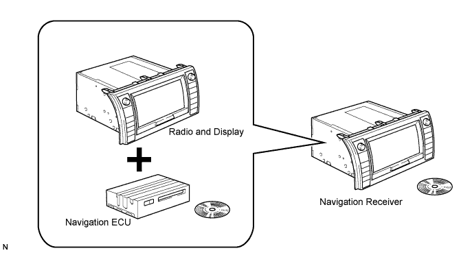
Conventionally, 2 separate devices, a "radio and display" and "navigation ECU", are used. In this model, these 2 devices are combined into a single unit.
NAVIGATION SYSTEM (for CrewMax) > SYSTEM DESCRIPTION |
| NAVIGATION RECEIVER OUTLINE |
Conventionally, 2 separate devices, a "radio and display" and "navigation ECU", are used. In this model, these 2 devices are combined into a single unit.
| NAVIGATION SYSTEM OUTLINE |
Vehicle position tracking methods
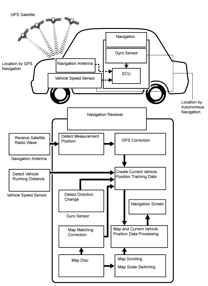
It is essential that the navigation system correctly tracks the current vehicle position and displays it on the map. There are 2 methods to track the current vehicle position: autonomous (dead reckoning) and GPS* (satellite) navigation. Both navigation methods are used in conjunction with each other.
| Operation | Description |
| Vehicle Position Calculation | Navigation receiver calculates current vehicle position (direction and current position) using direction deviation signal from gyro sensor and running distance signal from vehicle speed sensor, and creates driving route. |
| Map Display Processing | Navigation receiver processes vehicle position data, vehicle running track, and map data from map disc. |
| Map Matching | Map data from the map disc is compared to vehicle position and running track data. Then, vehicle position is matched with nearest road. |
| GPS Correction | Vehicle position is matched to position measured by GPS. Then, measurement position data from GPS unit is compared with vehicle position and running track data. If the position is very different, GPS measurement position is used. |
| Distance Correction | Running distance signal from vehicle speed sensor includes error caused by tire wear and slippage between tires and road surface. Distance correction is performed to account for this. Navigation receiver automatically offsets running distance signal to make up for difference between it and distance data of map. Offset is automatically updated. |
Autonomous navigation
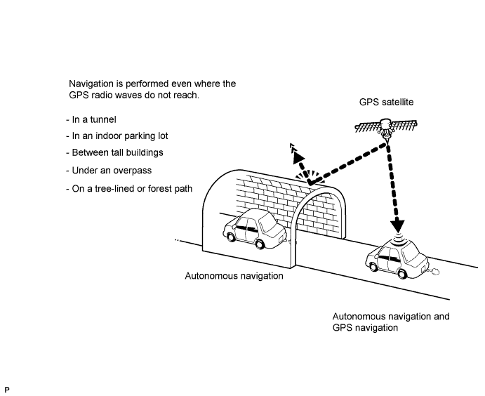
This method determines the relative vehicle position based on the running track determined by the gyro and vehicle speed sensors located in the navigation receiver.
Gyro sensor
Calculates the direction by detecting angular velocity. It is located in the navigation receiver.
Vehicle speed sensor
Used to calculate the vehicle running distance.
GPS navigation (Satellite navigation)
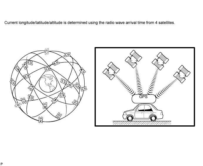
This method detects the absolute vehicle position using radio waves from a GPS satellite*.
| Number of satellites | Measurement | Description |
| 2 or less | Measurement impossible | Vehicle position cannot be obtained because number of satellites is not enough. |
| 3 | 2-dimensional measurement is possible | Vehicle position is obtained based on current longitude and latitude (this is less precise than 3-dimensional measurement). |
| 4 | 3-dimensional measurement is possible | Vehicle position is obtained based on current longitude, latitude and altitude. |
Map matching
The current driving route is calculated by autonomous navigation (according to the gyro sensor and vehicle speed sensor) and GPS navigation. This information is then compared with possible road shapes from the map data in the map disc and the vehicle position is set onto the most appropriate road.
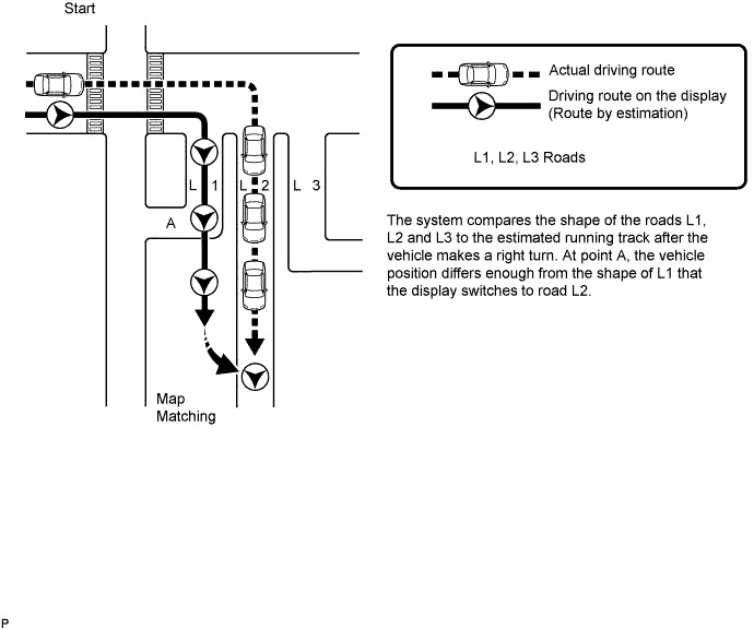
| NAVIGATION RECEIVER OUTLINE |
Touch switch
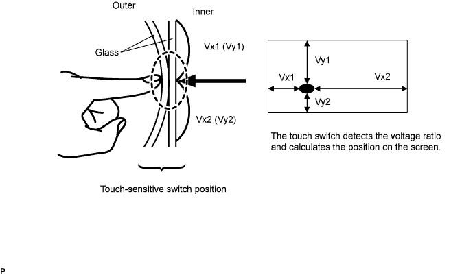
Touch switches are touch-sensitive (interactive) switches operated by touching the screen. When a switch is pressed, the outer glass bends to contact the inner glass at the pressed position. By doing this, the voltage ratio is measured and the pressed position is detected.
| DVD (Digital Versatile Disc) PLAYER OUTLINE (for Navigation Map) |
The navigation receiver uses a laser pickup to read the digital signals recorded on a DVD.
| DISC PLAYER OUTLINE |
The CD player has a 4-disc CD changer.
A CD player uses a laser pickup to read digital signals recorded on CDs. By converting the digital signals to analog, music and other content can be played.
Usable discs
CD player
This player can only play audio CDs, CD-Rs (CD-Recordable), and CD-RWs (CD-ReWritable) that have any of the following marks:
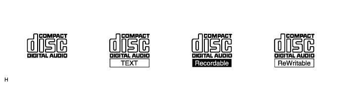
Precautions for handling disc
Cleaning
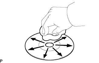 |
To clean dirty discs, use a dry, soft cloth such as those used for glasses with plastic lenses. Lightly wipe radially from the center of the disc.
| MP3/WMA OUTLINE |
Playable MP3 file standards
| Compatible standard | MP3 (MPEG1 LAYER3, MPEG2 LSF LAYER3) |
| Compatible sampling frequency |
|
| Compatible bit rate |
|
| Compatible channel mode | Stereo, joint stereo, dual channel, monaural |
Playable WMA file standards
| Compatible standard | WMA Ver. 7, 8, and 9 |
| Compatible sampling frequency | 32, 44.1, 48 (kHz) |
| Compatible bit rate |
|
ID3 tag and WMA tag
Additional textual information called ID3 tags can be input to MP3 files. Information such as song titles and artist names can be stored.
Additional textual information called WMA tags can be input to WMA files. Information such as song titles and artist names can be stored.
Usable media
Only CD-ROMs, CD-Rs (CD-Recordable), and CD-RWs (CD-ReWritable) can be used to play MP3/WMA files.
Usable media format
Usable media format
| Disc format | CD-ROM Mode 1, CD-ROM XA Mode 2 Form1 |
| File format | ISO9660 Level 1 and Level 2 (Joliet, Romeo) |
Standards and restrictions
| Maximum directory levels | 8 levels |
| Maximum number of characters for a folder name/file name | 32 characters |
| Maximum number of folders | 192 (Including empty folders, root folders, and folders that do not contain MP3/WMA files) |
| Maximum number of files in a disc | 255 (Including non-MP3/WMA files) |
File names
Only files with an extension of ".mp3" or ".wma" can be recognized and played as MP3 or WMA files.
Save MP3 or WMA files with an extension of ".mp3" or ".wma".
| "BLUETOOTH" OUTLINE |
"BLUETOOTH" is a trademark owned by "Bluetooth" SIG, Inc.
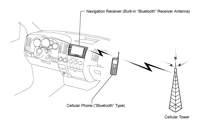
"Bluetooth" is a new wireless connection technology that uses the 2.4 GHz frequency band. This makes it possible to connect a cellular phone ("Bluetooth" capable phone*) to the navigation receiver ("Bluetooth" system is built-in) through the handsfree function of the cellular phone, even if it is in a pocket or bag. As a result, it is not necessary to directly connect the radio receiver to the cellular phone.
| AVC-LAN DESCRIPTION |
What is AVC-LAN?
AVC-LAN, an abbreviation for "Audio Visual Communication Local Area Network", is a united standard developed by the manufacturers in affiliation with Toyota Motor Corporation. This standard pertains to audio and visual signals as well as switch and communication signals.
Purpose:
Recently, car audio systems have rapidly developed and the functions have vastly changed. The conventional car audio system is being integrated with multimedia interfaces similar to those in navigation systems. At the same time, customers are demanding higher quality from their audio systems. This is merely an overview of the standardization background. The specific purposes are as follows:
To solve sound problems, etc. caused by using components of different manufacturers thorough signal standardization.
To allow each manufacturer to concentrate on developing products they do best. From this, reasonably priced products can be produced.
| COMMUNICATION SYSTEM OUTLINE |
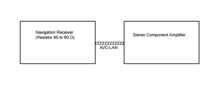
Components of the navigation system communicate with each other via the AVC-LAN.
The navigation receiver has enough resistance (60 to 80 Ω) necessary for transmitting the communication. This is essential for communication.
If a short circuit or open circuit occurs in the AVC-LAN circuit, communication is interrupted and the navigation system will stop functioning.
| DIAGNOSTIC FUNCTION OUTLINE |
The navigation system has a diagnostic function (the result is indicated on the master unit).
A 3-digit hexadecimal component code (physical address) is allocated to each component on the AVC-LAN. Using this code, the component in the diagnostic function can be displayed.